Guiding
Question
What Sanctuary resources might be affected in
the advent of a large-scale oil spill?
Materials
Discussion
|
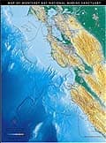
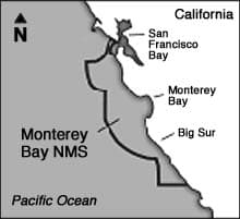
What Makes Monterey Bay National Marine
Sanctuary Special? Monterey Bay, the
largest of NOAA's marine sanctuaries,
hosts a rich array of habitats. Within its
boundaries lie rugged rocky shores, lush
kelp forests, and one of the deepest
underwater canyons on the west coast. The
canyon cuts more than 3,500 meters (2
miles) deep and reaches nearly 100
kilometers (60 miles) out to sea.
Sanctuary habitats abound with life, from
tiny plankton to huge blue whales. With
its great diversity of habitats and life,
the sanctuary is a national focus for
marine research and education program.
|
|
|
|
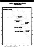
Habitats
|
|
|
Sandy beaches
|
Submarine canyon
|
|
Rocky shores
|
Pelagic, open ocean
|
|
Kelp forests
|
Wetlands
|
|
|
|
|
Key Species
|
|
|
Sea otter
|
Brown pelican
|
|
Gray whale
|
Rockfish
|
|
Market squid
|
Giant kelp
|
|
|
|
|
Cultural Resources
|
|
|
Indian midden sites
|
Naval airship USS Macon
|
|
|
|
|
Latitude and Longitude:
|
|
|
36° N 122° W
|
|
|
|
|
|
Web Site Address:
|
|
|
https://montereybay.noaa.gov
|
Procedure:
Part 1: What is a Marine Sanctuary?
|
1
|
On the board or overhead projector,
write the words "marine sanctuary." Tell
students that 13 national marine
sanctuaries have been set aside in the
United States since 1972.
|
|
2
|
Using the National Marine Sanctuaries
Background Information sheet as a guide,
describe to your students why marine
sanctuaries were established and how they
are managed. Start them thinking about
what marine sanctuaries are--establishing
what they already know and encouraging
them to ask and answer their own questions
about sanctuaries and the marine
environment.
|
|
3
|
Discuss with students the role of
national parks, both on land and at sea,
as special places that preserve algae,
plants, and animals, the habitats in which
they live, unique landforms, and
recreational opportunities for people.
Compare the establishment of the first
national park, Yellowstone, in 1872 to the
establishment of the first national marine
sanctuary, the sunken ship Monitor, about
one hundred years later.
|
Part 2: Using the MBNMS Map for an
Investigation
|
1
|
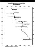
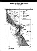
Using the poster-size MBNMS Map, as a
class, look at the scale and color bars in
the bottom left corner. Identify which
colors are urban areas (gray), ocean
(light & dark blue depending on
depth), low-lying croplands and coastal
wetlands (green).
|
|
2
|
Identify some of the dominant features
of the map. These might include Monterey
Bay, the city nearest your school, the
mountain ranges (Santa Lucia, Gabilan,
Santa Cruz, & Diablo Range), the
undersea canyons (Soquel, Carmel, &
Monterey), rivers leading to the Sanctuary
(Salinas, Pajaro, & San Lorenzo), and
Highway 1 and 101.
|
|
3
|
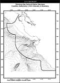
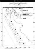
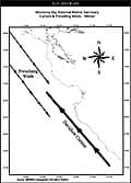
Discuss the use of Geographic
Information System (GIS) as a
technological tool for creating maps and
analyzing areas spatially. Using an
overhead projector and transparency copies
of GIS overlay sheets, briefly look at the
different types of data that scientists
have collected. For More GIS information
see: https://oceanservice.noaa.gov/websites/retiredsites/supp_sseretired.html
|
|
4
|
Explain that these images are created
from distinct GPS (Geographic Positioning
System) data points that are input into a
computer in units of longitude and
latitude.
|
|
5
|
Lay the GIS transparencies on top of
each other to demonstrate how GIS data is
considered multi-dimensional or spatial.
These overlays will be the informational
sources that students will use during
their mock public meeting
presentations.
|
|
6
|
Discuss the importance of monitoring natural areas in order
to identify if changes are due to natural or human disturbances.
Please refer to "Ecosystem Monitoring
in the Sanctuaries".
|
|
NOAA
ANNOUNCES $50,000 GRANT!
In response to today's environmental
disaster - when 300 million liters of
crude oil spilled in the Monterey Bay
Sanctuary - the National Oceanic &
Atmospheric Administration has directed
$50,000 toward emergency aid.
At 7:00 pm tonight there will be an
emergency public meeting at the town hall,
to consider where the funding will go and
what actions the public can take to
protect our coast and resources.
In order to have a voice in how the
funding is allocated, present your case to
the Monterey Bay Sanctuary Advisory
Council, and they will make the
appropriate recommendations to NOAA.
If interested in speaking, please
prepare a 5 minute presentation with
supporting graphics. You may sign-up upon
entry to the meeting. At the close of the
meeting, the Council will announce any
relevant actions and their funding
recommendations.
Please Join in this important
effort!
|
Part 3: What Resources Might be Affected by a
Major Oil Spill?
Students will represent six different community
groups. (See Oil Spill Activity Cards.)
The groups are:
- the Sanctuary Advisory Council, who will
preside over a public meeting. See inset "NOAA
Announces $50,000 Grant!"
- US Coast Guard Officers, who will report on
the situation as they see it.
- Park Rangers and Oil Spill Volunteers
- Scientists
- Fishing Industry Representatives
- Monterey Bay National Marine Sanctuary
Representatives
The last four groups will present their
perspective to the Council on how to mitigate (or
reduce) the negative environmental and economic
impacts that might occur due to the oil spill
event.
* IMPORTANT NOTE! There is a grant of
$50,000 that will be allocated to the community for
dealing with the oil spill's impact.
|
1
|
Divide the class into six groups. Each
group should receive one of the six
Activity Cards, an Oil Spill Scenario
sheet, and a Presentation Guidelines card.
The cards will explain each group's roles
and responsibilities.
|
|
2
|
Read the NOAA $50,000 Grant
Announcement (see following page) to the
class. Have each group discuss the
concerns and answer the questions raised
on its activity card.
|
|
3
|
Have each group give a five minute
presentation to the Sanctuary Advisory
Council following the rules listed in the
Presentation Guidelines handout.
|
|
OIL
SPILL ACTIVITY
CARDS
(ONE
SMALL CARD PER GROUP)
|
|
Panel
SANCTUARY ADVISORY
COUNCIL
Primary Concern: Which
community groups need funding?
How much? Members of this panel
may include a state park
official, a government official,
a scientist, an educator, a
business owner, a fishermen, and
a diver.
Panel's Task: Listen
objectively to all perspectives
and recommend to NOAA how the
$50,000 should be allocated. You
will deliberate after hearing all
presentations, and then announce
your decisions.
|
Oil Spill Response
Team
U.S. COAST GUARD
Primary concern: Assess
the situation and inform the
public of the oil spill location,
size, direction of movement,
potential for damage, etc.
Answer the Questions:
What area will be most
immediately affected? (plot
latitude & longitude) Refer
to the Oil Spill Scenario
sheet.
|
Stakeholder Group
#1
PARK RANGERS & OIL SPILL
VOLUNTEERS
Primary Concern: Impact
of the oil spill on wildlife and
sensitive habitats.
Answer the Questions:
How might the spill affect marine
animals and their habitat? How
much of the money, if any, should
be put toward rescue and
rehabilitation efforts?
|
Stakeholder Group
#2
SCIENTISTS (US Fish &
Wildlife biologists)
Primary Concern:
Longterm assessment of the oil
spill impact on wildlife &
natural areas.
Answer the
Questions:
How long will the environmental
impacts of the spill be felt?
How would a longterm
monitoring study assess this?
What types of monitoring
techniques are recommended?
(Surveys have varied costs
depending if they are on foot, by
boat or aerial).
|
Stakeholder Group
#3
FISHING INDUSTRY (fishermen,
seafood packers & seafood
markets)
Primary Concern: Impact
of oil spill on fishing
Answer the
Questions:
How might the oil spill affect
fishing, both presently & in
the future?
How much money might they
lose?
Can they seek reimbursement
from the government?
|
Stakeholder Group
#4
SANCTUARY STAFF (resource
managers, researchers &
educators)
Primary Concern: Impact
of oil spill on all Sanctuary
resources. MBNMS is a multi-use
area.
Answer the
Questions:
How can the MBNMS help coordinate
all the oil spill clean-up
operations?
How can the MBNMS support
research and monitoring
efforts?
|
|
a PDF version of this file can be found in the fullcurr.pdf
document (2.7mb)
|
OIL
SPILL SCENARIO
(one
card per group)
|
|
|
"On January 9th, 2000, a
350 meter cargo freighter
______________________ (your
school name),was traveling in a
dense fog, gale winds and heavy
seas. At 9:00 pm, the freighter
collided with an oil tanker
called _____________________
(another school) which was
carrying 300 million liters of
crude oil. The bow of the
freighter was slightly damaged,
but was in no risk of sinking.
The oil tanker, however,
sustained heavy damage to its
midsection. It was leaking oil
into the ocean and is in danger
of sinking."
The US Coast Guard station
in Monterey received a distress
signals from both ships and
informed the MBNMS of the
disaster. Here are the details of
the situation.
|
Tanker
Position:
|
Latitude: 36
degrees 40 minutes
north
|
|
|
Longitude: 123
degrees 10 minutes
west
|
|
Wind
Speed:
|
35 knots from the
NW
|
|
Sea
Condition:
|
5 meter
waves
|
|
Vessel
Damage:
|
Oil from both the
cargo freighter and the
tanker was seen on the
surface. The oil tanker
was definitely sinking.
The freighter was dead
in the water
|
|
|
|
PRESENTATION
GUIDELINES
(one
card per group)
|
|
|
The Sanctuary Advisory
Council is composed of 20
federally-appointed
representatives from government
agencies, local institutions, and
user groups (diving, fishing,
harbors, agriculture) concerned
with the resources of the
Monterey Bay National Marine
Sanctuary. One student group will
represent the council members,
and will sit in the front facing
the rest of the audience. Their
role is to advise NOAA on issues
important to the community.
Your stakeholder group must
develop and present a clear and
persuasive argument to the
Council members. You want them to
clearly understand what your
needs are, and why you deserve a
good portion of the $50,000 that
is available. The funding is
available for clean-up efforts,
research and monitoring, and to
help mitigate (reduce) the
negative effects of the spill.
PRESENTATION RULES
• Each team will have
five minutes to present its case
to the Sanctuary Advisory Council
(SAC).
• Your presentation
should be colorful and
informative and include the use
of color graphics such as the
poster-size map and/or GIS
overlays with an overhead
projector.
• Look through the GIS
overlays to find those of
importance to your group. Explain
why those particular resources
are most important to your
community group, and how they are
or will be affected.
• At the closing of
each presentation, there will be
five additional minutes allotted
for questions and comments from
the rest of the audience who have
come to participate in this
public meeting.
• At the conclusion of
all the presentations, the SAC
will then deliberate and inform
the audience of the
recommendations it will provide
to NOAA. NOAA will then allocate
the funds accordingly.
|
|
a PDF version of this file can be found in the fullcurr.pdf
document (2.7mb)
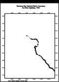
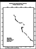
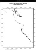
GIS
Overlays
a PDF version of these images can be found in the
fullcurr.pdf document (2.7mb)
|
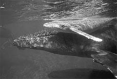 Humpback
mother and calf © Dave
Matilla
Humpback
mother and calf © Dave
Matilla