Watershed Assesment Reports for Pescadero-Butano & Upper Pajaro River
 Upper Pajaro River Sediment Assessment
The Pajaro River Watershed is one of the largest riverine systems entering the Monterey Bay and drains an area of approximately 1,300 square miles of land on the Central Coast of California. The Upper Pajaro River Sediment Assessment was developed for the 202 square miles of the upper northeastern portions of the watershed. The assessment characterizes erosion and sedimentation dynamics in Llagas and Uvas Creeks, including an evaluation of sediment conditions, erosion risk, and potential impacts to beneficial uses with the watershed.
The assessment was done in conjunction with landowner outreach by the Santa Clara County Farm Bureau, as part of the Sanctuary's Agriculture and Rural Lands Plan. This assessment was managed by the Monterey Bay National Marine Sanctuary Foundation and funded by a grant from the State Water Resources Control Board.
- Final Report, (46MB PDF)
Pescadero-Butano Watershed Assessment
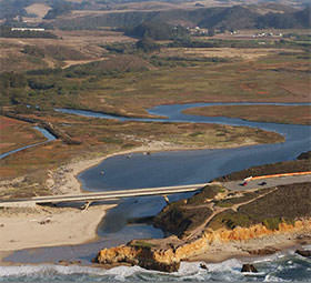
The Pescadero-Butano watershed is the largest coastal watershed between the Golden Gate and the San Lorenzo River. The watershed's two principal streams, Pescadero Creek and Butano Creek, which have their confluence in Pescadero Marsh, drain 81 square miles of the Santa Cruz Mountains and the coastal valleys, hills, and terraces around the town of Pescadero.
The Pescadero-Butano Watershed Assessment was undertaken to assess current habitat conditions for Coho salmon and Steelhead trout in the watershed, characterize sediment sources and dynamics, and identify factors limiting the quality and extent of salmonid habitat. The overall goal of the project is to develop a scientific basis for future management plans and actions related to restoration and the salmonid fishery.
The assessment was done in conjunction with agricultural demonstration projects developed by the San Mateo County Farm Bureau, as part of the Sanctuary's Agriculture and Rural Lands Plan. Coastal Watershed Council conducted water quality monitoring with a team of volunteers. This assessment was managed by the Monterey Bay National Marine Sanctuary Foundation and funded by a 319(h) grant from the State Water Resources Control Board.
- Final Report, (8.3MB PDF)