Resource Issues: Coastal Armoring and Erosion
Click here for information on the 2014 Coastal Regional Sediment Management Plan For Santa Cruz Littoral Cell Project
Introduction
 About 85% of the California coast experiences active erosion due to natural, and anthropogenic causes. Storm damage continually erodes away at the coastline, most notably during El Niño years such as the 1982-83 episode, and other heavy storms1. This ongoing erosion, which is largely a natural occurrence, presents a threat to coastal development that has occurred in areas vulnerable to these processes. Hard surfaces, such as concrete, cover large portions of land, impede the natural absorption of water, and thus exacerbate surficial erosion on adjacent unprotected land. Furthermore, in some areas, natural sand transport to the coast has been decreased through the damming of streams and rivers. Increases in coastal development also have led to storm-related damage2. A 1992 study by Griggs, Pepper and Jordan estimated that the cost of storm related damage and erosion, as well as structures used to mitigate the destruction throughout the state of California, averaged $100 million annually3.
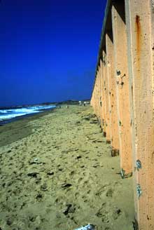
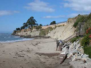
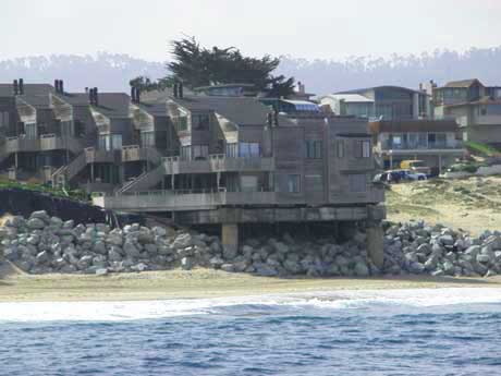
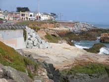
Shoreline protective structures have been used extensively along California's 1,200 mile coastline to protect infrastructure and other development from wave action, or to retain soil to avoid erosion. Shoreline protective structures have typically been installed by private landowners, local, state, or federal governments, in an attempt to protect development threatened by erosion. Structures have also been installed in response to the need to protect public infrastructure such as Highway 1, which in some stretches, is vulnerable to erosion related to bluff retreat. This practice is commonly known as coastal armoring, and seawalls, bulkheads and revetments are some of the structures used for coastal armoring. Seawalls are barriers, usually vertical walls, between the land and water that protect from wave erosion. A bulkhead is used as a retainer, providing protection and stabilizing the land that it supports. Revetments are protective structures placed along slopes and are constructed of a sturdy material such as stone4. With increases in development and continued natural erosion of coastal bluffs, additional pressures will come to install structures both to access the coast and to protect private and public property from erosion.
 The Army Corps of Engineers conducted an assessment of coastal armoring in 1971, and found that 3 miles of the coastline between the Santa Cruz/San Mateo County border (all in the City of Santa Cruz), and Point Lobos in Monterey County was armored. By 1978 armoring had increased to 9.6 miles, and by 1993, armoring had increased to 12 miles. A 1995 report of the California Coastal Commission (Commission) estimated that if trends continue, there would be as much as 27.7 miles of coastal armoring in the same area, in the future. The report stated that although only one-eighth of the study area was armored in 1995, one-third of the coastline has the potential to warrant future protection when considering land use patterns and physical characteristics5.
The trends in Santa Cruz and Monterey Counties are typical of the state. By 1998, coastal armoring had been installed to protect about twelve percent (or almost one-eighth) of the coastline statewide. The mid and late 1980's was a period when a large amount of shoreline armoring was installed—in response to the 1982/83 El Niño and the major storms that occurred in 1986 and 1988. Between 1985 and 1990, forty-five miles of armoring was installed, costing an average of $1,500 per foot ($60 million/year). By 1998, California residents were paying more than $75 million per year to armor the shoreline6. In a study conducted by Griggs et al., in 1992, it was determined that ocean front development has occurred in California in the face of a large amount of scientific and empirical evidence regarding the risks of erosion. Griggs et al. also concluded that there was a large degree of inconsistency among existing state and local policies in addressing coastal hazards, and furthermore that there was a significant economic and local political influence shaping these policies7.
Development occurrs in vulnerable areas along California's coast, and is followed by a desire to protect both private/public property and infrastructure. The situation presents a serious predicament to both resource managers and property owners. However, it is clear that current policies need strengthening, and there is a need to develop collaborative approaches to address the issues of erosion and the demand for coastal armoring, including improved guidance to enable better decision-making.
Impacts of Coastal Armoring
Environmental impacts of coastal armoring are both site specific and cumulative. The effects vary significantly depending on the type of structure constructed, the magnitude of the project, and the specific geological, biological, and oceanographic conditions in the vicinity of the structure. Thus the impacts of an individual project need to be evaluated on a case-by-case basis. Coastal armoring can potentially damage or alter local coastal habitats, deprive beaches of sand, lead to accelerated erosion of adjacent beaches, hinder access and present problems with public safety.
 As with any activity that alters natural processes, there can be significant long-term impacts related to coastal armoring. Currents, waves, and wind normally transport sediment throughout the littoral system. Armoring of the coast can interfere with littoral transport, which in a natural state may reach a dynamic equilibrium. When the availability of sediment is reduced due to the existence of a structure, erosion can increase in other nearby locations. This is due to starvation of the materials that would normally supply these areas. When a structure is constructed, a supply of sediment is effectively being cut off. Armoring also causes deflection of wave energy, which can accelerate erosion of nearby sites, expanding the need for shoreline armoring structures. In some cases, installing coastal armoring begets more coastal armoring. Furthermore, armoring can result in the loss of beach and intertidal areas through a process that has been termed “passive erosion." Areas that undergoing long-term net erosion experience a natural landward movement of the entire beach system during periods of sea level rise; such has been the case for approximately the last 18,000 years. As cliffs and sand dunes retreat, the vacated area becomes part of the beach environment and the position of the beach shifts landward. Building a protective structure in front of a cliff or dune temporarily stabilizes the seaward location of the cliff or dune edge, however beach erosion continues. Since no new beach area is created through cliff or dune retreat, a net loss of beach area occurs. Ultimately, as erosion continues, this process also will result in the loss of the intertidal zone, as waves impact the seawall at all times, low tide as well as high.
Vertical structures in particular can deflect wave energy causing increased erosion and altering natural habitat in front of the structure. Reflected wave energy may make it difficult for organisms to inhabit the area because of high turbidity. Erosion caused by the reflection of wave energy is more severe with vertical structures than with curved, stepped, or inclined structures, which absorb or disperse the energy of the waves. The significance of this reflected wave energy will vary, depending upon how frequently the wall is inundated or impacted by waves, and how much the reflective characteristics of the wall differ from the natural shoreline8. A wall that is only subject to wave attack once a decade would only alter the reflected wave energy once a decade. Also, a vertical bluff and a vertical wall would have fairly similar reflective characteristics, while a dune and a vertical wall would be very different.
Potential biological impacts of coastal armoring include changes in abundance and distribution of species. Coastal armoring structures can influence the structure of benthic communities, due to potential differences in settlement patterns for natural substrates and armoring structures. Armoring structures can encroach into the intertidal, or disturb important buffer areas such as marsh habitat between the marine and terrestrial environments, which naturally mitigate erosion, and play an important role in flushing of certain contaminants9. Certain structures can also provide habitat for predatory species not normally associated with the beach and intertidal zone such as rats and squirrels, which can feed on intertidal organisms, compete for food with native species, and transmit disease.
 Seawalls can have recreational impacts as well, by blocking both vertical and lateral access to beaches, and altering wave patterns, which can negatively impact surfing conditions. Additionally, coastal armoring can act as a barrier to wildlife, by blocking access of certain species to the beach.
Environmental impacts that occur during the construction phase of coastal armoring projects are generally short term, lasting only a few days to a few weeks. Problems include increased turbidity caused by suspended solids in the immediate vicinity of the construction site, and the risk of chemicals or other materials entering the ocean from construction activities. Structures constructed in the intertidal zone have more impact than those constructed above the high tide line. Certain types of structures such as riprap revetments have fewer initial impacts than other hard structures, since construction normally requires significantly less excavation than, for example, a seawall. Permanent impacts of revetments however, are similar to those of seawalls, and the footprint of the revetment is typically larger. Many short-term construction impacts can be minimized through appropriate mitigation. Mitigation measures include scheduling of the construction phase to reduce impacts by considering animal migration patterns, spawning patterns, etc., and specific actions such as the use of silt curtains10.
Existing MBNMS Regulations
Sanctuary regulations prohibit alteration of the seabed, and all armoring structures placed below the mean high tide line require approval from the MBNMS. The Sanctuary regulates coastal armoring by authorizing Commission permits, and issuing specific conditions on those permits. Many seawalls have been constructed with no notification to or authorization from MBNMS. Throughout its first decade, MBNMS' review of seawalls primarily focused on minimizing impacts from the construction process rather than long-term impacts from the armoring itself. However in 2002, as part of its management plan update process, the Sanctuary shifted focus to conducting long-term planning as to the consequences of coastal armoring and its effect on some of the Sanctuary's most treasured resources, its beaches, bluffs, and coastline.
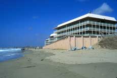
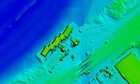 LIDAR imaging technology of the erosion patterns around the Monterey Beach Resort's seawall. |
A NOAA response to a comment urging the Sanctuary to prohibit the construction of seawalls, in the MBNMS Final Environmental Impact Statement states: “Activities that require drilling into, dredging, or otherwise altering the seabed of the Sanctuary, or constructing, placing, or abandoning any structure, material, or other matter on the seabed of the Sanctuary are prohibited (with a few exceptions) except as allowed under 15CFR § 944.11 or exempted under activities related to the maintenance of harbors. Seawall construction would not be allowed." This statement clearly indicates the intent to prohibit seawall construction that is inconsistent with current and past practices. Nonetheless, the regulations adopted for the Sanctuary allow Sanctuary management to allow development, otherwise prohibited, by “authorizing" other agencies' permits, such as the Coastal Commission. There are three activities that MBNMS regulations expressly do not allow a sanctuary manager to permit: oil and gas development, designating new dredge disposal sites, and new sewage outfalls. The express regulatory prohibitions for which permits cannot be issued do not include seawalls. Thus MBNMS staff has interpreted this response to comment in the context of the regulatory framework set up in 1992.
How is the Sanctuary currently involved?
Development along the coast increases the pressure to protect coastal structures with various types of coastal armoring such as seawalls, bulkheads and revetments to manage erosion. Approximately 14 miles of the approximately 290 miles of coastline is already armored in the MBNMS, and this amount is estimated to double if trends continue11.
The MBNMS has been addressing the issues of coastal erosion and armoring in the context of updating the Sanctuary's Management Plan, as well as in reviewing and authorizing permit applications that involve disturbance of the seabed. As part of its revised management plan, the MBNMS has developed an action plan addressing coastal erosion and armoring issues. The goal of this action plan is to reduce expansion of hard coastal armoring in the coastal areas near the MBNMS through proactive regional planning, project tracking, and comprehensive permit analysis and compliance. This action plan recommends developing a more proactive and comprehensive regional approach that minimizes the negative impacts of coastal armoring on a Sanctuary-wide basis.
Consistent with the Coastal Armoring Action Plan, the Southern Monterey Bay Coastal Erosion Workgroup was initiated in 2005 by the MBNMS, in collaboration with state and local partners, to facilitate the development of a regional approach to coastal erosion within the Southern Monterey Bay region between the Salinas River and Wharf 2 in Monterey. The 20-member workgroup is made up of scientists, federal and state agencies, local governmental representatives, conservation interests and other local experts. The goals of the SMBCEW are to: compile and analyze existing information on erosion rates and geomorphology in the region, as well as identify corresponding critical erosion areas, including threats to private and public structures within the Southern Monterey Bay (SMB) region; identify and assess the complete range of options available for responding to erosion in the region; and, based upon the above analyses, to develop a proactive and comprehensive regional shoreline preservation, restoration, and management plan with selected site-specific and broader area-wide recommendations for responding to coastal erosion that minimize environmental and socioeconomic impacts to the maximum extent feasible.
To date, the SMBCEW has:
- Compiled and analyzed existing information on erosion rates and geomorphology of the region and developed a background report;
- Developed a complete list of critical erosion areas in the SMB region, compiled information about the background of each site, and prioritized these areas based upon level of threat;
- Identified a wide range of options available for responding to erosion and completed initial assessments assessing which approaches or combinations of approaches might be appropriate at each of the sites on the critical erosion area list;
- Identified seven planning sub-regions within the larger southern Monterey Bay region;
- Conducted public workshops
- Provided input on a Coastal Regional Sediment Management Plan for the SMB littoral cell.
One of the primary goals for the SMBCEW is to identify and assess the range of options available for responding to erosion, and to pursue alternatives that go beyond the responses that have been used in the past, which are primarily seawalls and revetments. A recent study found that erosion rates along the southern Monterey Bay shoreline between Moss Landing and Wharf II in Monterey are the highest in the State of California. Although this shoreline is not heavily developed, eight oceanfront facilities are at a high risk from erosion over the next fifty years. A 2012 sanctuary-led report, Evaluation of Erosion Mitigation Alternatives for Southern Monterey Bay, reviewed 22 erosion mitigation measures appropriate for this region. Where possible, alternatives should have minimal impacts to biological and geological marine resources, maintain beach width, and lateral and vertical public access.
The study found erosion mitigation measures previously not considered feasible would be substantially more beneficial than those currently used, such as seawalls and other onshore structures. For Southern Monterey Bay, it was estimated there would be a $1.25 billion net benefit over the next century by allowing coastal erosion to continue as opposed to the traditional response of seawall construction. The most promising approaches would be cessation of sand mining, rolling easements and beach nourishment.
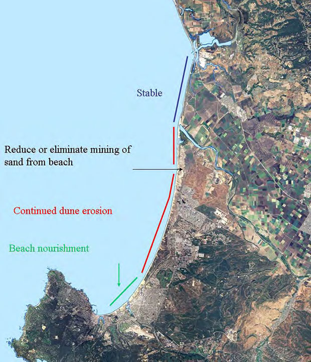 Summary of the key recommendations from the 2008 Coastal Regional Sediment Management Plan for Southern Monterey Bay Littoral Cell which extends from Moss Landing to Point Pinos in Pacific Grove. Recommendations include cessation of sand mining from the beach, continuation of natural dune erosion in the less developed reaches, and a sand nourishment project to provide additional storm protection. |
The workgroup is working toward the ultimate goal of developing a proactive regional plan for the SMB shoreline, which will include identification/assessment of potential site specific and sub-regional alternatives for addressing coastal erosion, to include recommendations as to when and where specific alternatives should be used. It is hoped that this process will result in a reduction of hard coastal armoring and maintenance of beach width in the SMB region.
The SMBCEW process has already begun to result in a better understanding of the coastal processes, and increased knowledge of issues surrounding coastal erosion and armoring in the SMB region among local decision makers, landowners, and the general public, and also increased information sharing and collaboration, and development of partnerships among permitting agencies, researchers, and other stakeholders. MBNMS is currently working with the US Army Corps and interested stakeholders to facilitate the Coastal Regional Sediment Management Plan for the Santa Cruz Littoral Cell. Click here for information on this 2014 project.
OTHER RESOURCES:
- Coastal Sediment Management Workgroup
- CSMW Spatial Data Website
- California's Beach Erosion Control Program
- USGS National Assessment of Shoreline Change Project
- USGS Pleasure Point Study
- California Coastal Commission
- California State Coastal Conservancy
- Pacific Institute Report: The Impacts of Sea-Level Rise on the California Coast
- Littoral Cells, Sand Budgets, and Beaches: Understanding California's Shoreline
DOWNLOADABLE DOCUMENTS (PDF):
- Evaluation of Erosion Mitigation Alternatives for Southern Monterey Bay Report 5/30/12 (4.2MB PDF)
- MBNMS Coastal Armoring Action Plan (718K PDF*)
- Coastal Regional Sediment Management Plan for Southern Monterey Bay (24.1MB PDF*)
- Coastal Erosion and Armoring in Southern Monterey Bay (1.5MB PDF*)
- The Impacts of Coastal Protection Structures in California's Monterey Bay National Marine Sanctuary (700KB PDF*)
- Are "Stable Shorelines" and "Broad Beaches" Mutually Exclusive Management Goals Along Southern Monterey Bay? (1.5MB PDF*)
- Sand Budgets for California's Major Littoral Cells (19.5MB PDF*)
- Cumulative Losses of Sand to the California Coast by Dam Impoundment (1.4MB PDF*)
CITATIONS:
- California Resources Agency. Draft Policy on Coastal Erosion Planning and Response and Background Material. March, 2001
- California Resources Agency. March, 2001.
- Griggs, Gary B., Pepper, James E. and Jordan, Martha. California's Coastal Hazards: A Critical Assessment of Existing Land-use Policies and Practices. California Policy Seminar, University of California. 1992.
- U.S. Army Corps of Engineers. Engineer Manual. Design of Coastal Revtments, Seawalls, and Bulkheads. 1995.
- California Coastal Commission. ReCAP Pilot Project Findings and Recommendations: Monterey Bay Region. September, 1995.
- Griggs, Gary. California Needs a Coastal Hazard Policy. Coast and Ocean Magazine. Volume 13, No. 3. 1998.
http://www.coastalconservancy.ca.gov/coast&ocean/autumn98/a04.htm. - Monterey Bay National Marine Sanctuary Final Environmental Impact Statement/Management Plan. Appendix F, Page 36. June, 1992.
- Griggs, Pepper and Jordan. 1992
- U.S. Army Corps of Engineers. 1995
- U.S. Army Corps of Engineers. 1995
- U.S. Army Corps of Engineers. 1995
- California Coastal Commission. 1995
Funding
This project is funded from Med Taipei restoration funding.